About 18,000 years ago, we had Ice age when the sea level was lower by 130 metres than what it is now. Due to de-glaciation, the sea level rose.
Around 7,300 years back, there was major flooding and the sea level rose to 4 metres more than what it is today. This has been verified by several researchers throughout the world. But the bridge that connects India and Sri Lanka is different; it is not just a sand dune.
Have studies been done on this particular phenomenon?
We (Geological Survey of India) were asked to carry out surveys for locating the Sethu Samudram Canal project by the project authorities in 2004-05.
Any startling revelations?
When we reached near Adam's Bridge, there was sudden rise in the land level. From about 10-12 metre, it rose one metre to half a metre. So, our vessel could not go and survey the area. In some areas, we did survey using small boats.
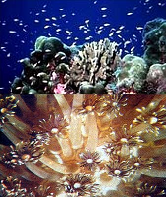
The northern side of Adam's Bridge is the rough Palk Bay, which is prone to periodic cyclonic storms, and the tranquil southern side is the Gulf of Mannar, which is unpolluted and pristine.
Corals grew in the tranquil Gulf of Mannar but not in the turbulent Palk Bay as they grow only in tranquil waters. There are about 21 islands full of corals in the Gulf of Mannar side but not even a single coral on the northern side of Adam's Bridge.
Image: Dr Badrinarayanan feels the Sethu Samudram Project could pose a threat to corals in the region.