 | « Back to article | Print this article |
Sparkling PHOTOS of cities from the night sky
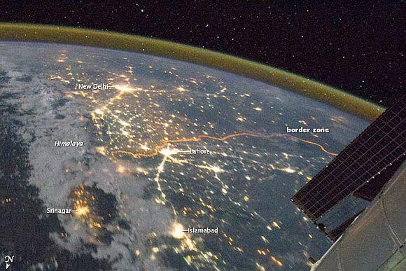
Clusters of yellow lights on the Indo-Gangetic Plain reveal numerous cities large and small in this astronaut photograph of northern India and northern Pakistan.
Of the hundreds of clusters, the largest are the capital cities of Islamabad, Pakistan, and New Delhi, India. (For scale, these metropolitan areas are approximately 700 kilometers or 435 miles apart.) The lines of major highways connecting the cities also stand out. More subtle, but still visible at night, are the general outlines of the towering and partly cloud-covered Himalayas to the north (image left).
This image was taken with a 16 mm lens, which provides the wide field of view, as the International Space Station was tracking towards the southeast across India. The ISS crew took the image as part of a continuous series of frames, each with a one-second exposure time to maximise light collection. Unfortunately, this also causes blurring of some ground features.
Click on NEXT to see more PHOTOS...
Sparkling PHOTOS of cities from the night sky
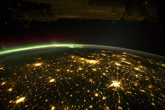
When viewed from the International Space Station, the night skies are illuminated with light from many sources.
For example, the Midwestern United States presents a nighttime appearance not unlike a patchwork quilt when viewed from orbit.
The artificial light from human settlements appears with a characteristic yellow tinge. The green light of theaurora borealis also shines brightly in this view -- even seeming to reflect off Earth's surface in Canada. A small white patch of light is almost certainly lightning from a storm on the East Coast (image top right). Part of the ISS appears across the top of the image.
Click on NEXT to see more PHOTOS...
Sparkling PHOTOS of cities from the night sky
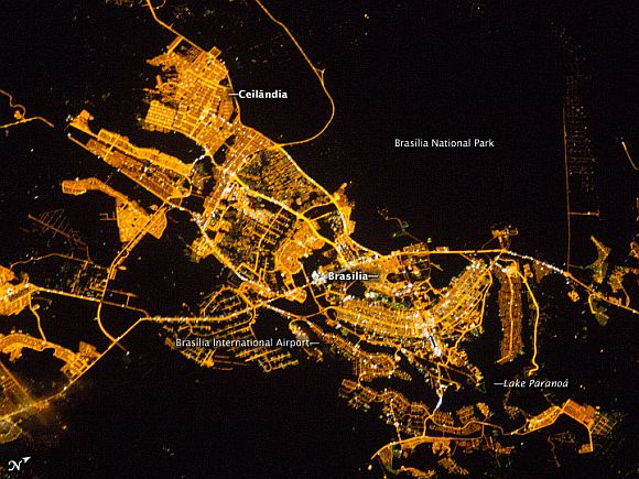
Whether seen at night or during the day, the capital city of Brazil is unmistakable from orbit.
Brasilia is located on a plateau -- the Planalto Central -- in the west-central part of the country, and is widely considered to be one of the best examples of 20th century urban planning in the world. One of its most distinctive design features -- as seen from above -- suggests a bird, butterfly, or airplane traveling along a northwest-southeast direction, and is made dramatically visible by city light patterns (image centre right, between Lake Paranoa and the airport).
Following the establishment of Brasilia in the early 1960s, informal settlements began to form around the original planned city. Ceilandia was one such settlement. In 1970, Ceilandia was formalised by the government and is now a satellite city of Brasilia with its own distinct urban identity.
The developed areas of Brasilia and its satellites are clearly outlined by street grids and highway lights in this astronaut photograph taken from the ISS. The large unlit region to the upper right is the Brasilia National Park. Other dark regions to the bottom and left include agricultural fields and expanses of the Cerrado tropical savanna.
Click on NEXT to see more PHOTOS...
Sparkling PHOTOS of cities from the night sky
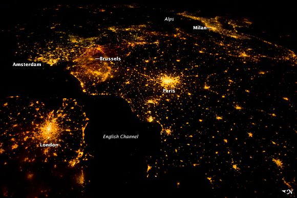
Several of the oldest cities of northwestern Europe are highlighted in this astronaut photograph from just after midnight (00:25 Greenwich Mean Time) on August 10 this year.
While the landscape is dotted with clusters of lights from individual urban areas, the metropolitan areas of London, Paris, Brussels, and Amsterdam stand out due to their large light 'footprints'. The metropolitan area of Milan is also visible at image upper right. While each of these cities is, or has been, the capital of a kingdom, republic, or empire -- Paris and London have been all three -- Brussels is also the capital city of the European Union.
This photograph from the ISS was taken with a short camera lens, providing the large field of view. To give a sense of scale, the centres of the London and Paris metropolitan areas are approximately 340 kilometers (210 miles) from each other. The image is also oblique -- taken looking outwards at an angle from the ISS, which tends to foreshorten the image -- making the distance between Paris and Milan (640 kilometers, or 400 miles) appear less than that of Paris to London.
Click on NEXT to see more PHOTOS...
Sparkling PHOTOS of cities from the night sky
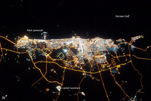
The city of Dubai is the largest metropolitan area in the emirate of Dubai, one of the member states of the United Arab Emirates. Dubai is located along the southern Persian Gulf on the Arabian Peninsula, and its signature city is known for high profile architectural and development projects.
Among the most notable is the Palm Jumeirah, a man-made peninsula and surrounding islands built from over 50 million cubic meters of sand. Three other island projects, two similar to Palm Jumeirah and another crafted to look like a map of the world, are also underway along the Dubai coastline.
This nighttime astronaut photograph of the city of Dubai was taken at approximately 2 am local time on September 11, 2009. Orange sodium vapour lights trace the major highways and street grid in and around the metropolitan area, while grey-white mercury vapor lamps fill in the commercial and residential areas. The lighted islands and peninsula of Palm Jumeirah are clearly visible along the coastline. A spiral pattern of lights on the southeastern fringe of the urban area is a camel racetrack. Night time images like these are useful to climate modelers, urban planners, and geographers as they allow for simple definition of urban (densely lit) and rural (sparely lit) areas.
Click on NEXT to see more PHOTOS..
Sparkling PHOTOS of cities from the night sky
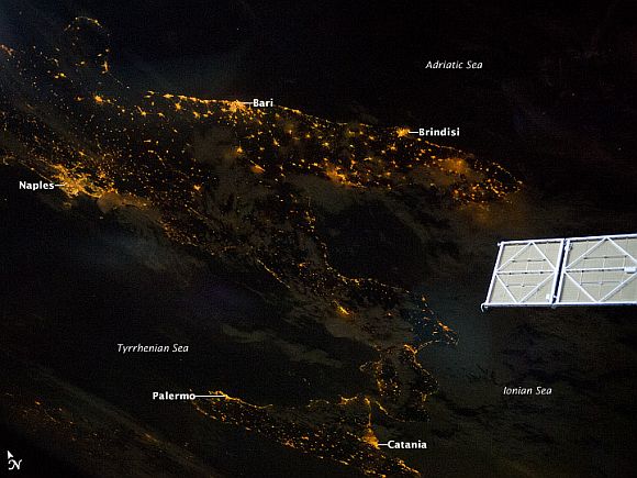
At night, Earth's surface is covered with a delicate tracery of lights, particularly in regions that have a long history of urban development (such as Europe).
Large urban areas are recognisable from orbit due to extensive electric lighting and distinct street patterns. With smaller urban areas spread across the land surface and coastlines, the outlines of continental land masses are easily discernable at night.
This astronaut photograph highlights the night time appearance of the southern Italian Peninsula. The toe and heel of Italy's 'boot' are clearly defined by the lights of large cities such as Naples, Bari, and Brindisi, as well as numerous smaller cities and towns. The bordering Adriatic, Tyrrhenian, and Ionian Seas appear as dark regions to the east, west, and south. The city lights of Palermo and Catania, Sicily, are also visible.
Click on NEXT to see more PHOTOS...
Sparkling PHOTOS of cities from the night sky
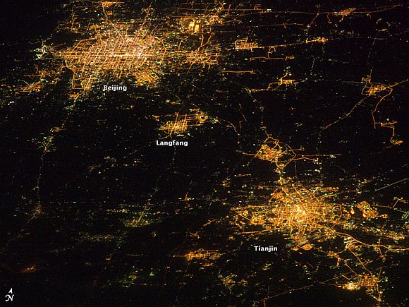
Night time images have a way of dramatically revealing the amount of land development in metropolitan areas. This astronaut photograph features two of China's most populous cities -- Beijing and Tianjin -- both in the northeastern part of the country near the Bohai Gulf. The United Nations estimated the 2010 population of the Beijing metropolitan area to be approximately 12 million, with the population of Tianjin estimated at more than 7 million.
The smaller city of Langfang, located midway between Beijing and Tianjin, is also clearly visible, as are several smaller developments to the northeast. The dark regions are mainly agricultural fields, with wheat and corn being the major crops.
Beijing (also known as Peking) is one of the ancient capital cities and the current capital of the People's Republic of China.
Its regular grid pattern is clearly visible at image upper left; concentric rings of major roadways around the city have been added as the metropolitan area has expanded. Tianjin is a major trade centre linked to seaports on the Bohai Gulf. The city lies along the Grand Canal of China, a major artificial waterway extending southward for 1,176 kilometers (1,103 miles) from Beijing to Hangzhou.
Click on NEXT to see more PHOTOS...
Sparkling PHOTOS of cities from the night sky
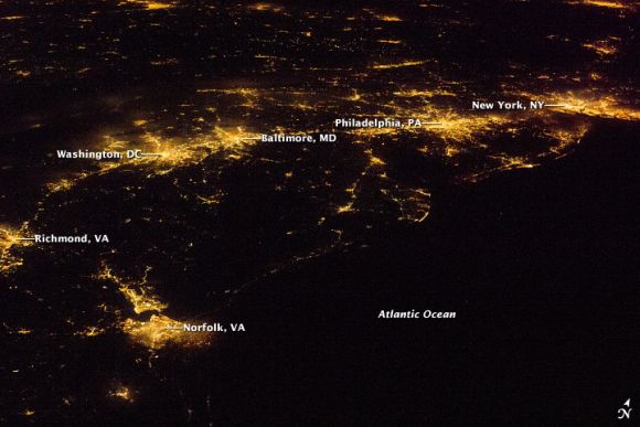
As metropolitan areas expand in both physical area and population, they typically aggregate to form economically, politically and, to some extent, socially linked entities known as conurbations. The term 'megalopolis' has also been used.
One of the largest conurbations in the world is located along East Coast of the United States, and has been termed the Atlantic Seaboard Conurbation. The ASC extends over 1,000 kilometers (600 miles) and includes the major economic, governmental, and cultural centres of Boston, Massachusetts; New York City, New York; Philadelphia, Pennsylvania; Baltimore, Maryland and Washington, District of Columbia.
This astronaut photograph includes every metropolitan area in the ASC except for Boston (located off the image to the northeast). This night image highlights the position and extent of each metropolitan area through urban lighting patterns. The establishment and growth of the conurbation was facilitated by transportation networks -- railroads, highways, and air travel routes -- for the transfer of goods, materials, and population between the cities.
Click on NEXT to see more PHOTOS...
Sparkling PHOTOS of cities from the night sky
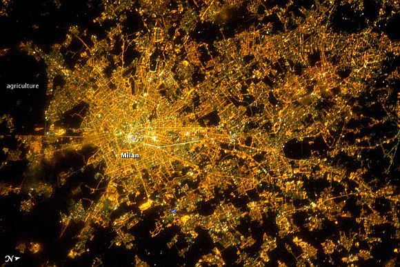
The metropolitan area of Milan (or Milano) illuminates the Italian region of Lombardy in a pattern evocative of a patchwork quilt. The city of Milan forms a dense cluster of lights in this astronaut photograph, with brilliant white lights indicating the historic centre of the city where the Duomo di Milano (Milan Cathedral) is located.
Large dark regions to the south (image left) contain mostly agricultural fields. To the north, numerous smaller cities are interspersed with agricultural fields, giving way to forested areas as one approaches the Italian Alps (not shown). Low, patchy clouds diffuse the city lights, producing isolated regions that appear blurred.
The Milan urban area is located within the Po Valley, a large plain bordered by the Adriatic Sea to the east-southeast, the Italian Alps to the north, and the Ligurian Sea and Appenines Mountains to the south.
Click on NEXT to see more PHOTOS...
Sparkling PHOTOS of cities from the night sky
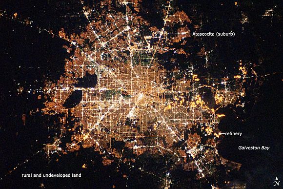
Houston, Texas, has been called the 'energy capital of the world' due to its role as a major hub of the petroleum and other energy resource industries.
The Houston metropolitan area covers almost 2,331,000 hectares (9,000 square miles) along the southeast Texas coastline, with an average elevation of 13 metres (43 feet) above sea level and a population of over 5 million (2006 US Census estimate).
The Houston metropolitan area is also noteworthy as being the largest in the United States without formal zoning restrictions on where and how people can build. This freedom has led to a highly diverse pattern of land use at the neighborhood level nevertheless, more general spatial patterns of land use can be recognised in remotely sensed data. These general patterns are particularly evident in night time photography of the urban area taken by astronauts on board the ISS.
The image depicts the roughly 100-kilometre (60-mile) east-west extent of the Houston metropolitan area. Houston proper is at image centre, indicated by a 'bull's-eye' of elliptical white- to orange-lighted beltways and brightly lit white freeways radiating outwards from the central downtown area. Suburban and primarily residential urban areas are indicated by both reddish-brown and gray-green lighted regions, which indicate a higher proportion of tree cover and lower light density.
Click on NEXT to see more PHOTOS...
Sparkling PHOTOS of cities from the night sky
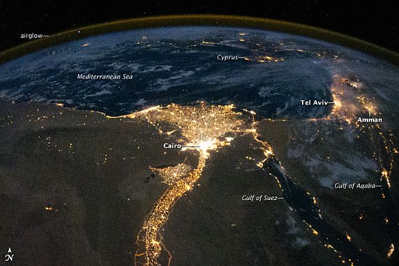
The Nile River and its delta look like a brilliant, long-stemmed flower in this astronaut photograph of the southeastern Mediterranean Sea, as seen from the ISS. The Cairo metropolitan area forms a particularly bright base of the flower.
The smaller cities and towns within the Nile Delta tend to be hard to see amidst the dense agricultural vegetation during the day. However, these settled areas and the connecting roads between them become clearly visible at night. Likewise, urbanised regions and infrastructure along the Nile River becomes apparent (see also The Great Bend of Nile, Day & Night.)
Another brightly lit region is visible along the eastern coastline of the Mediterranean -- the Tel-Aviv metropolitan area in Israel (image right). To the east of Tel-Aviv lies Amman, Jordan. The two major water bodies that define the western and eastern coastlines of the Sinai Peninsula -- the Gulf of Suez and the Gulf of Aqaba -- are outlined by lights along their coastlines (image lower right). The city lights of Paphos, Limassol, Larnaca, and Nicosia are visible on the island of Cyprus (image top).
Click on NEXT to see more PHOTOS...
Sparkling PHOTOS of cities from the night sky
The brightly lit metropolitan areas of Torino (Italy), Lyon, and Marseille (both in France) stand out amidst numerous smaller urban areas in this dramatic astronaut photograph.
The image captures the night time appearance of the France-Italy border. The southwestern end of the Alps Mountains separates the two countries. The island of Corsica is visible in the Ligurian Sea to the south (image top).
The full moon reflects brightly on the water surface and also illuminates the tops of low patchy clouds over the border (image centre). This image was taken by an ISS astronaut at approximately 11:55 p.m. local time, when the ISS was located over the France-Belgium border near Luxembourg.
