Several occasions in the last two decades have seen government agencies and research studies warning about potential glacial lake outburst floods (GLOFs) in Sikkim, which can cause massive damage to life and property.

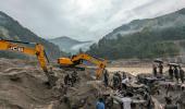
A GLOF occurred in parts of Lhonak Lake, leading to a rapid rise in water levels with very high velocities downstream along the Teesta River Basin in the early hours of October 4. This resulted in severe damage in Mangan, Gangtok, Pakyong and Namchi districts.
According to the Sikkim State Disaster Management Authority (SSDMA), 14 people have lost their lives, and 102 others, including 22 army personnel, are missing after the GLOF event.
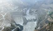
The incident also resulted in the breach of the Chungthang dam, a crucial component of the 1,200-megawatt (MW) Teesta Stage III Hydro Electric Project, the largest hydropower project in the state.
GLOFs occur when lakes formed by melting glaciers suddenly burst open. This can happen due to various reasons, such as excessive water accumulation in the lake or triggers like earthquakes.
When the lake bursts, it releases an enormous volume of water all at once, causing flash floods downstream. These floods can be extremely destructive and perilous for both people and the environment in the affected area.
According to the South Asia Network of Dams, Rivers, and People, south Lhonak Lake is a glacial-moraine-dammed lake situated in Sikkim's far northwestern region. It is one of the fastest-expanding lakes in the Sikkim Himalaya region and is classified as one of the 14 potentially dangerous lakes susceptible to GLOFs.
The lake is situated at an altitude of 5,200 m (17,100 ft) above sea level and formed due to the melting of the Lhonak glacier. The lake's size is rapidly increasing due to the melting of the lake's associated South Lhonak glacier and additional meltwater from the adjacent North Lhonak and main Lhonak glaciers.
Satellite images from the Hyderabad-based National Remote Sensing Centre showed that the area of south Lhonak Lake drastically reduced from 167.4 hectares on September 28 to 60.3 hectares on October 4, confirming a GLOF event that caused massive damage in the Teesta River basin.
A study conducted by the National Remote Sensing Centre and the Indian Space Research Organisation in 2012-2013 discussed the formation of a moraine-dammed glacial lake at the snout of the South Lhonak glacier and the associated risks.
"The (south Lhonak) lake outburst probability shows a very high value of 42 percent for the lake, and the peak discharge estimated using the empirical formula shows a discharge of 586 m3/s," the study said.
In 2016, the Sikkim government's Department of Science and Technology conducted an expedition to estimate the lake's volume, led by Sonam Wangchuk of the Ladakh-based NGO Students' Educational and Cultural Movement of Ladakh. The expedition warned about the potential of a GLOF event.
Dilliram Dahal, Assistant Professor at Namchi Government College, Sikkim, revealed that high-density polyethylene pipes were installed to siphon off water from the glacial lake following the expedition to prevent a GLOF event.
In September this year, officials from the DST, SSDMA, and the Land and Revenue Department conducted another inspection at the lake to install an early warning system and automatic weather station.
A study published in the journal ELSEVIER in 2021 identified south Lhonak Lake as potentially dangerous with a high outburst probability.
"In Sikkim, the lake-terminating glaciers have shown accelerated growth compared to glaciers without lakes. South Lhonak glacier is no different; it is one of the fastest-retreating glaciers, and the associated proglacial lake (south Lhonak Lake) has become the largest and fastest-growing in the state. The glacier receded approximately 2 km in 46 years from 1962 to 2008 and retreated another 400 m from 2008 to 2019. This has raised concerns about the hazard potential of this lake, as the downstream valley is heavily populated with numerous settlements and infrastructure," the study highlighted.
The Sikkim Human Development Report of 2001 also cautioned about a "serious potential hazard" from GLOFs in Sikkim.
"Disturbances in mountain ecology have started attracting considerable attention. The phenomenon of jokulhlaup (glacier leap), also known as glacial lake outburst floods (GLOF), is a frequent and alarming occurrence in Sikkim. As the state is dotted with many glaciers, this is a serious potential hazard," the report read.


 © 2025